

- 13-Year-Old Apratim’s Death Leaves Cumilla in Grief |
- Iran Sets 3 Conditions to End War and Resume US Talks |
- PM Urges World Leaders to Work Together to Achieve SDGs |
- ‘Violence will only defer a problem’: UN Assembly President |
- Ninth Pay Scale Gazette Issued, Higher Salaries From July |
A 20-metre road, eight months underwater in Kushtia
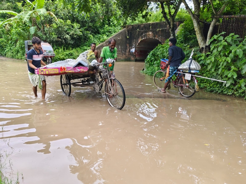
A section of road in Kumarkhali upazila of Kushtia remains under water for eight months in a year.
By Al Mamun Sagor
Kushtia, Aug 3 (UNB) -For nearly eight to ten months every year, crossing a barely 20 metres stretch of road becomes an ordeal for thousands of people in Kumarkhali upazila of Kushtia.
Submerged under knee-deep water for most of the year, the road beneath a British-era railway tunnel in Hatisako area has become a symbol of chronic neglect, disrupting daily life for nearly 100,000 residents of Koya and Nandalalpur unions.
What was once a vital transport link has gradually turned into a bottleneck, with poor drainage and unplanned land filling trapping rainwater for months at a time.
A Daily Struggle
Every monsoon, the road disappears beneath stagnant water. Schoolchildren roll up their uniforms and carry their bags over their heads. Office-goers wade through the murky water before beginning their workday. Easy-bikes and vans frequently break down midway, leaving passengers stranded.
A recent visit to the area found knee-deep water covering both approaches to the tunnel, forcing commuters to navigate the flooded road on foot or risk damaging their vehicles.
For many residents, this is not an occasional inconvenience but a reality they have endured for years.
Only Road to the Upazila
According to Koya Union Parishad Chairman Md Ali Hossain, the road serves as the only direct route to the upazila headquarters for around 70,000 people in his union.
"The water has nowhere to go because there is no drainage system," he said.
He explained that raising the road level is not a practical solution, as vehicles would then struggle to pass through the low-clearance railway tunnel.
"What was built during the British period has now become a source of suffering in modern times," he said, alleging that repeated appeals to the authorities have produced little progress.
How the Problem Began
Residents said the railway tunnel was constructed during British rule to maintain communication across the area.
For decades, rainwater naturally drained through surrounding lowlands into nearby wetlands. But over the last ten years, many of those open spaces have been filled to build houses, shops and other structures.
With the natural drainage channels blocked and no engineered drainage system in place, rainwater now accumulates around the tunnel and remains there for months.
By the time the stagnant water begins to recede, another rainy season often arrives.
Vehicles Damaged, Livelihoods Affected
The prolonged waterlogging has also taken a financial toll on transport operators.
Easy-bike driver Raja Ali said the flooded road frequently damages vehicle batteries and motors.
"The battery gets short-circuited and the motor is damaged. I spend between Tk 5,000 and Tk 7,000 every month on repairs," he said.
Many drivers avoid the route altogether, forcing passengers to walk through the flooded section or take longer alternative roads.
Students Pay the Price
For schoolchildren, the flooded road has become a barrier to education.
Umme Maria, a ninth-grade student at Alauddin Nagar Secondary School, said she used to cycle to school before the road became regularly submerged.
"One day I fell because the damaged road was hidden beneath the water. Now I walk or travel by van," she said.
Another student, seventh-grader Huzaifa Rahman, said he has no choice but to walk through the water every day.
"My books, notebooks and school uniform often get wet. Sometimes I cannot even attend classes. It is affecting my studies," he said.
Long Detours
Those unwilling to wade through the flooded road must travel an additional three to four kilometres using alternative routes.
Pedestrians Rezaul Islam and Md Shantu said the detour increases both travel time and transportation costs.
"We need a planned solution instead of temporary fixes," they said.
Changing Landscape
Sixty-five-year-old farmer Bishu Sikder recalled a time when the area was surrounded by open land.
"Earlier, rainwater flowed through highway pipes into nearby wetlands," he said.
"Now people have filled the land to build houses and shops. There is simply no outlet for the water."
Nearby resident Rozina Khatun said water begins accumulating during the monsoon and often remains until the Bengali months of Chaitra and Baishakh.
"Before the water dries up completely, the rains return again. The road stays underwater for more than eight months every year," she said.
Authorities Cite Structural Challenges
Engineer Md Nazmul Haque of Kumarkhali Upazila LGED, acknowledged the drainage problem, saying the area lacks any proper drainage infrastructure.
According to him, resolving the waterlogging would require constructing a culvert on the adjacent highway to allow water to flow out, a project beyond the jurisdiction of the Local Government Engineering Department (LGED).
Upazila Nirbahi Officer Farzana Akhter said the administration is discussing the matter with higher authorities.
She expressed hope that a planned development project could be undertaken once the necessary approvals and funding are secured.
Until then, however, road measuring only 20 metres continues to test the patience—and resilience—of thousands of people every single day. - UNB