

- Dry Monsoon in South Asia: Looming Fears of Agricultural Loss |
- Flood-ravaged Nepal calls for climate justice |
- If Long March Solved Energy Crisis, We’d Organise It: PM |
- Freedom of speech should not cross limits of civility: PM |
- Bangladesh Condemns Israeli Settlement Plan in West Bank |
Interview: Every disaster also presents an opportunity to learn
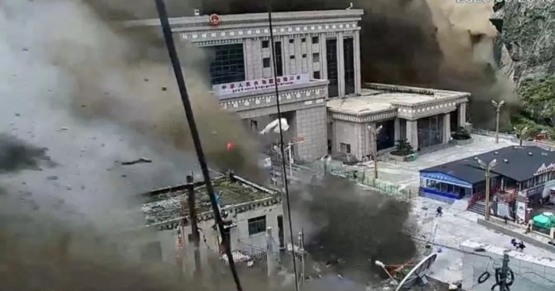
Glacial collapse-induced Floods wreak havoc to Nepal and Tibet, AP Photo
September 10, 2026SANDRP
Q: “This incident has indicated that the risks we face in the Himalayan region are increasing with climate change,” said Nepal Prime Minister Balendra Shah. Can we just blame it all on climate change and ignore the role aggressive development poses in an ecologically fragile zone? Or is climate change indeed the main villain?
ANS: Climate Change is a likely trigger for the Rasuwa flood disaster that Nepal and Tibet are facing, starting from the morning of Aug 26, 2026, though the scientists say this needs further studies. But the extent of the disaster depends on a number of factors including callous way in which major interventions have been taken up in the region, including large number of hydropower projects, knowing fully well the inherent vulnerabilities of the Himalayan region accentuated by climate change, by lack of early warning systems, absence of functioning disaster management system including emergency action plans.
Feature image above: Nepal Army rescues people trapped inside hydropower tunnels on Trishuli River Photo: PMO Office, Nepal video
Lack of land use policy & practices that are informed by the vulnerabilities of the area is another major factor. This is apparent from the way schools and buildings have been devastated along the path of the rivers during the disaster.
The development plans also do not seem to have fully taken into account the disaster history of the area, including the floods this very region faced in July 2025 and Sept 2024. This is also apparent from the website of Asian Development Bank (ADB) among other funders that are funding the Upper Trishuli 1 Hydropower project. The Cumulative Impact Assessment study done by the World Bank’s International Finance Corporation which too is funding the Upper Trishuli 1 project does not even properly assess the impacts of the hydropower projects across the Trishuli river basin.
In December 2024, an independent panel of experts appointed by ADB visited the site as a part of routine monitoring. In their report they wrote that “no climate resilience assessment was undertaken for the Project – this is a significant gap”. It recommended that such an assessment be conducted. In May 2025, the ADB panel found that the assessment “has yet to be done”.
While the international banks’ own reports repeatedly highlighted climate risks, they did not take any preventive steps, did not demand stringent checks and balances, nor were they prepared for a calamity they knew could occur, they did not have any effective early warning systems nor emergency action plan. The banks, shockingly, funded the projects in the name of climate and disaster resilience. The banks’ failures were particularly serious because they violated their own policies.
The panel had recommended that the project’s “early warning system” should be redesigned “as soon as possible”. By May 2025, not much had changed. “The slow implementation of a reliable early flood warning system… remains a major risk to those project communities in proximity to the river,” the panel’s report noted. The panel also found that muck from the project was being disposed of directly in the river, a practice that is known to worsen the impacts of floods.
A siren was supposed to go off if water suddenly rose near the tunnel on Upper Trishuli 1 project, or even if there was any other emergency. It did not work on the fateful day of Aug 26, showing criminal callousness.
It was also found that an early warning system installed 10 km upstream at the Chilime hydropower project “proved to be useless” for the flood in September 2024. The Chilime project has been severely impacted by the flood in 2026 disaster and at least eight of its workers are missing.
IFC’s Cumulative Impact Assessment (CIA) did not discuss the threats of glacial lake outburst floods and flood disasters. The Upper Trishuli basin has more than 36 hydropower projects, but the CIA did not even attempt to look upstream and assess impacts related to the Tibetan catchment. It made no cumulative disaster plan for the basin.
The Asian Development Bank’s panel of independent experts overseeing the Upper Trishuli-1 project had recommended strengthening the warning system and emergency plan, coordinating alerts with hydropower projects upstream and downstream, and putting evacuation protocols in place for dangerous floods. Practically none of these was done with any effectiveness. The Chinese Exim bank supporting the Trishuli 3A Hydropower project does not even follow any of these policies, no impact assessment or other related reports are in public domain.
There was an agreement between the presidents—Xi Jinping of China and Bidya Devi Bhandari of Nepal—in 2019, committing to promote cooperation in addressing climate change and protecting the environment, among other subjects. However, the two countries do not have even a rudimentary joint early warning plan in shared river basins.
Throughout Himalayas, shoddy or dishonest Environment Impact Assessments, lack of accountability in governance and non-implementation of basic monitoring, forecasting and implementable disaster management plans is worsening the disaster impacts in river valleys with multiple hydropower projects. By not doing independent post-disaster impact assessments, we have shut the doors for learning any lessons for the future.
Q: Taking for granted that development activities will not stop, or that climate change cannot be reversed, what precautions can be adopted for safety in geologically sensitive zones that are also affected by climate change?
ANS: Indeed, the need is not to stop development activities, but select appropriate development options keeping in mind the realities of the region. The first requirements is to recognise and accept the geological and other vulnerabilities of the Himalayan region. Secondly, accept the added vulnerabilities due to climate change. This will now also include the melting permafrost and threats of collapse of hanging glacier, also due to landslides, avalanches involving rocks and ice. It also means need for monitoring and early warning systems.
We need much better appraisals, including environment and social impact assessments (today they are mostly in namesake), disaster vulnerability assessments and democratic decision making processes. The impact assessments will include credible options assessments. We also need disaster management plans that begin with early warning systems, but not stop at that. There has to be a management system that includes sharing plans as to what to do with the various kind of information from early warning systems and that also includes accountability in governance.
Every disaster is also an opportunity to learning lessons. One of the first step in that direction would be an assessment by an independent panel after every disaster. We will also need a basin wise credible cumulative impact assessments. In all these we need to have governance system that recognises independent track records and also conflict of interest.
Q: News reports say that there had been warning signs of the glacier collapse. What role does technology play when it comes to early warnings?
ANS: In the Aug 2026 Rasuwa flood disaster, the trigger seems to be the collapse of hanging glacier through a height of about 1200 meters, the kinetic energy from the fall melted the ice and began a flow in the nearby Linde Khola river, which then flowed into Bhote Koshi (west) and Trishuli Rivers. This kind of collapse of hanging glacier is not easy to monitor, scientists have said.
However, technology certainly has a big role to play here. The monitoring of identified vulnerable areas in remote location will largely have to be through radars and satellites, hoping that as our understanding improves, the monitoring will provide actionable information. We need a disaster management system that should be in able to use this information. We have repeatedly seen that many times there is no system in place to use such information to reduce the disaster proportions. This was the case in Uttarakhand disaster of June 2013, Chamoli disaster of Feb 2021 and Sikkim GLOF disaster of Oct 2023, among others. An independent review is likely to reach similar conclusion for the current disaster.
For example, we have an inventory of hanging glaciers in Alaknanda, Kali, Upper Yamuna and Bhagirathi basin done by Indian Universities. They have prioritised hanging glaciers based on size and vulnerability. If an automated surveillance and EWS of the entire upper watershed is too expansive, then at least vulnerable sites have to be identified based on studies and they should be monitored specifically not only by satellite and radar but through an in-situ system which sends alarm in real time to downstream communities, projects and decision makers. These sites may include hanging glaciers, expanding glacial lakes, unstable slopes, receding glaciers, melting permafrost slopes, etc.
Q: If warnings are heeded, can they lessen the impact of floods, at least in downstream areas?
ANS: Indeed, if the disaster management system is in place to use the information from a functioning early warning system, whether formal or informal, it can help hugely in reducing deaths and damages in the downstream areas.
A good example of this is from an informal early warning we saw in case of Chamoli disaster of Feb 2021, where there was no formal early warning system. That informal early warning from Mangshri Devi, a village woman saved at least 25 lives including that of her son. Devi, from her hut at a height above the river bed, that morning, suddenly saw the approaching flood in the river from around a corner. She immediately called her son, working lower down, at the hydropower project and asked him to just get out of the project and rush upwards. His son first ignored her pleas, but when he finally saw the approaching flood wave, he ran, also alerting other worked around him, all of whom ran up the slope and saved their lives.
In case of Teesta GLOF disaster in October 2023, Sikkim SDMA got information about the risk to Chungthang population just past midnight of Oct 3, in the nick of time before the flood arrived, and quickly evacuated the population at risk. Further downstream, people around Teesta Bazar in W Bengal were also alerted and evacuated before the flood arrived there.
In fact, an ITBP (Indo-Tibetan Border Police) Jawan, stationed just 8 km from the South Lhonak lake, was the first to raise alarm. By 10.50 pm of Oct 3 night, this alert had already reached Chungthang, including the Teesta 3 dam authorities, and also further downstream projects. But the Teesta 3 dam authorities do not seem to have realised the gravity of the situation and did practically nothing in the precious over an hour of time they got before the flood hit the Dam. Had they acted and opened up the dam gates and emptied it before the flood arrived, that may have helped reduce the downstream impact. This is a classic case where early information was available, but action was not taken to use that information.
Almost similar situation prevailed during the June 2013 Uttarakhand disaster when a helicopter circled Kedarnath, came back after seeing the shrine area destroyed by the flood, but did not use that information to alert the downstream areas.
In case of operation of dams during monsoon, if the downstream dams, using the information from upstream catchment, take advance action to release stored water, they can help reduce the downstream floods, as we have repeatedly seen. We have also seen large number of examples, where such advance action has not been taken, leading to avoidable flood disaster in the downstream areas.
Q: What lessons do the Nepal floods hold for India?
ANS: India needs to intensify the monitoring of priority vulnerable locations identified in credible way, using satellites, radars, periodic physical visits. Involving the local communities is very important since the local communities are most knowledgeable about the local ecosystems, they are also the most at risk. We also need to put in place clearly listed actions that the different sections of the society are supposed to take up when a particular early warning is issued. There should be clearly defined role of various key persons in this regard. On Transboundary river basins, we should have the monitoring, information sharing protocol, joint research and possibly action plan with the neighbouring countries.
We also urgently need land use policy in vulnerable locations and review of existing structures in light of such a policy. Today we have none and we end up having more and more buildings in vulnerable locations. We also need to do a thorough, independent review of all dams and hydropower projects taking into account all the vulnerabilities and debris flow that these projects are likely to face under different single, and multi-cause, compound cause and cascading cause disasters. Such reviews must be done preferably by independent panel and should be in public domain, along with emergency action plans, to be periodically reviewed.
In all this we need to keep in mind the new threats in terms of weakening permafrost, possibility of collapse of hanging glaciers along with landslides, erosion, GLOFs, seismic activities and rising temperatures. We also need to review our under-construction and planned dams and hydropower projects in view of above.
Here we need to keep in mind the performance of China in current disaster. The bureaucratic response that China initially gave that the disaster started in Nepal and not in China sounded rather hollow when China was accused of not sharing available information in time. China’s inability to reach the affected area for over two days and subsequent very slow progress in terms of rescue and relief measures also does not speak well about China. The fact that China is funding and constructing a major hydropower project in this very vulnerable region, without any safety measure in place is another area of concern.
All this becomes relevant and concerning considering that the same China is in the process of building the World’s largest capacity hydropower project upstream of India on Yarlung Tsangpo river. A project that China itself once said, is the world’s most risky, the most expensive and the most technically challenging project. All the risks seen in Trishuli basin is several times larger in Yarlung Tansgpo basin. So India needs to urgently, publicly demand from China the basic information about the project and also demand a joint impact assessment, information sharing and monitoring mechanism. That would be much better than pushing an unjustifiable major hydropower project in that fragile Siang basin, in the name of neutralising the impacts of Chinese dam when we don’t even know the basic dimensions of the Chinese project.
Himanshu Thakkar (ht.sandrp@gmail.com)
https://sandrp.in/2026/09/10/interview-every-disaster-also-presents-an-opportunity-to-learn/